
ZL180 Handheld GPS for Surveying, High Precision Rugged Land Surveying Equipment for Ranches, Garden, Farmland and Parking Area Distance Measuring


Buy Now, Pay Later
- – 6-month term
- – No impact on credit to apply
- – Instant approval decision
- – Secure and straightforward checkout
Ready to go? Add this product to your cart and select a plan during checkout.
Payment plans are offered through our trusted finance partners Klarna, Affirm, Afterpay, Zip, Apple Pay, and Google Pay. No-credit-needed leasing options through Acima may also be available at checkout.
Learn more about financing & leasing here.
FREE 30-day refund/replacement
To qualify for a full refund, items must be returned in their original, unused condition. If an item is returned in a used, damaged, or materially different state, you may be granted a partial refund.
To initiate a return, please visit our Returns Center.
View our full returns policy here.
Recently Viewed


Features
- HIGH PRECISION ACCURACY: 2 high sensitivity satellites global GPS + GLONASS coverage for reliable surveying around the world, support for fast positioning and a reliable signal,area measurement error in 0.003 acres,it cannot be used for saving waypoints and navigation
- LARGE LCD: Our Product has a 2.4 inch FSTN panel and equipped with LCD backlight display, the measurement results can be displayed on the screen directly, convenient for observation
- RUGGED DESIGN: Our Product has a weight of approximately 180g/6.3oz and is compact, making it easy to carry. Adopts humanized groove design, easy to hold and not easy to fall off when using
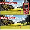
- 4 IN 1 MEASUREMENT: 2 types of area measurement methods that can measure garden parking lot ranch and flat field.2 distance measurement that can measure straight and curve line distance
- !!! PLEASE NOTE:Please search satellite signals in an open outdoor area before using this device and there is no signal can be found indoors.When the signal value in the upper left corner of the device screen is below 1 m, start measuring to ensure the accuracy of this device
- TIPS: Recommended to measure an area above 0.16 acres and distance above 328 ft. The larger the measurement range, the smaller the error.The device needed to be held horizontal when measuring
- NOTE:The altitude data displayed on the device is GPS altitude, and it changes with Satellite Signal.This is normal!This device only be used for surveying land and cannot be used for saving waypoint and navigation
Brand: NiesahYan
Screen Size: 2.4 Inches
Special Feature: Waterproof
Connectivity Technology: USB
Map Type: Topographical
Included Components: GPS, Sensor
Mounting Type: Handheld
Operating System: Windows
Touch Screen Type: Capacitive
Display Type: LCD
Screen Size: 2.4 Inches
Additional Features: Waterproof
Connectivity Technology: USB
Map Types: Topographical
Mounting Type: Handheld
Operating System: Windows
Touch Screen Type: Capacitive
Display Type: LCD
Human-Interface Input: Touchscreen
Control Method: Touch
Are Batteries Included: Yes
Supported Satellite Navigation System: GLONASS, GPS
Brand: NiesahYan
Built-In Media: GPS, Sensor
Manufacturer: NiesahYan
Frequently asked questions
To initiate a return, please visit our Returns Center.
View our full returns policy here.
- Klarna Financing
- Affirm Pay in 4
- Affirm Financing
- Afterpay Financing
- Zip Pay in 4
- Financing through Apple Pay
- Financing through Google Pay
Learn more about financing & leasing here.


