Prime Day deals end soon! View Deals
Search  for anything...

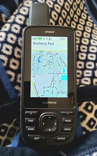
Garmin GPSMAP 67i Rugged GPS Handheld with inReach® Satellite Technology, Two-Way Messaging, Interactive SOS, Mapping

  • Based on 359 reviews
Condition: New
Checking for the best price...
$649.99 Why this price?
Prime Day Deal · 78% off was $2,899.99

Buy Now, Pay Later


As low as / mo
  • – Up to 36-month term if approved
  • – No impact on credit to apply
  • – Instant approval decision
  • – Secure and straightforward checkout

Ready to go? Add this product to your cart and select a plan during checkout.

Payment plans are offered through our trusted finance partners Klarna, Affirm, Afterpay, Apple Pay, and PayTomorrow. No-credit-needed leasing options through Acima may also be available at checkout.

Learn more about financing & leasing here.

Selected Option

Free shipping on this product

This item is eligible for return within 30 days of receipt

To qualify for a full refund, items must be returned in their original, unused condition. If an item is returned in a used, damaged, or materially different state, you may be granted a partial refund.

To initiate a return, please visit our Returns Center.

View our full returns policy here.


Availability: Only 6 left in stock, order soon!
Fulfilled by Amazon

Arrives Tuesday, Jun 30
Order within 16 hours and 4 minutes
Available payment plans shown during checkout

Protection Plan Protect Your Purchase
Checking for protection plans...

Style: InReach Technology


Features

  • Large 3 sunlight-readable color display for easy viewing
  • Enable two-way messaging and location tracking via the 100% global Iridium satellite network, and trigger an interactive SOS to Garmin ResponseSM, a 24/7 staffed emergency response coordination center (active subscription required; some jurisdictions regulate or prohibit the use of satellite communications devices)
  • Access preloaded TopoActive mapping from Garmin, view satellite imagery, and navigate with multi-band GNSS support and sensors
  • When paired with your compatible smartphone, you can access active weather forecasts and Geocaching Live
  • Use with the Garmin Explore website or app on your compatible smartphone to help you plan trips and more
  • Get access to a wide variety of premium mapping content delivered directly to your device via Wi-Fi technology with an Outdoor Maps+ subscription
  • Internal, rechargeable lithium battery provides up to 165 hours in 10-minute tracking mode and up to 425 hours in expedition mode with 30-minute tracking intervals

Description

Go explore the outdoors — and stay connected to home — with the GPSMAP® 67i handheld. Using inReach® technology, this button-operated GPS handheld and satellite communicator enables two-way messaging and location tracking (active subscription required; some jurisdictions regulate or prohibit the use of satellite communications devices). You can also trigger an interactive SOS to Garmin Response℠, a 24/7 staffed emergency response coordination center. Navigate confidently with preloaded TopoActive mapping and satellite imagery. When paired with your compatible smartphone, you can access active weather forecasts and Geocaching Live. Use the Garmin Explore™ website or app on your compatible smartphone to help you plan trips and more, and download premium maps with an Outdoor Maps+ subscription. During extended activities, turn on expedition mode for up to 425 hours of battery life in 30-minute tracking mode.

Brand: Garmin


Model Name: Garmin GPSMAP 67 series


Vehicle Service Type: Car, motorcycle


Screen Size: 3 Inches


Special Feature: Bluetooth


Connectivity Technology: Bluetooth, USB


Map Type: North America


Included Components: GPSMAP 67 or GPSMAP 67i handheld device, type-A to type-C USB cable, carabiner clip, documentation


Battery Life: 165 Hours


Mounting Type: Wrist Mount


Compatible with Vehicle Type: Car, motorcycle


Screen Size: 3 Inches


Additional Features: Bluetooth


Connectivity Technology: Bluetooth, USB


Map Types: North America


Battery Average Life: 165 Hours


Mounting Type: Wrist Mount


Memory Storage Capacity: 16 GB


Touch Screen Type: Capacitive


Display Type: Transflective Color TFT


Human-Interface Input: Buttons


Compatible Devices: Android, iPhone


Control Method: App


Are Batteries Included: Yes


Supported Satellite Navigation System: GPS


Sport Type: Camping & Hiking, Outdoor Lifestyle


Brand: Garmin


Model Name: Garmin GPSMAP 67 series


Built-In Media: GPSMAP 67 or GPSMAP 67i handheld device, type-A to type-C USB cable, carabiner clip, documentation


Model Year: 2023


UPC: 753759308636


Manufacturer: Garmin


Model Number: 010-02812-00


Mfr Part Number: 010-02812-00


Warranty Description: 1 year limited warranty


Item Type Name: Handheld GPS


Unit Count: 1.0 Count


Item Dimensions L x W x H: 3"L x 7"W x 2"H


Item Weight: 8.1 Ounces


Frequently asked questions

If you place your order now, the estimated arrival date for this product is: Tuesday, Jun 30

Yes, absolutely! You may return this product for a full refund within 30 days of receiving it.

To initiate a return, please visit our Returns Center.

View our full returns policy here.

  • Klarna Financing
  • Affirm Pay in 4
  • Affirm Financing
  • Afterpay Financing
  • PayTomorrow Financing
  • Financing through Apple Pay
Leasing options through Acima may also be available during checkout.

Learn more about financing & leasing here.

Top Amazon Reviews


  • Reliable and Feature-Packed GPS Device
Style: Standard
I’ve been using the Garmin products for a while now, and they've proven to be a highly reliable GPS manufacturer. Pros: The GPSMAP 67 offers extremely accurate tracking and navigation. It quickly locks onto satellite signals, even in dense forests or remote areas, providing consistent and reliable location data. It comes preloaded with detailed maps, and the ability to add more maps is a huge plus. This is perfect for outdoor enthusiasts who need various types of terrain maps at their fingertips. One of the standout features is its impressive battery life. It can last for several days on a single charge when used intermittently, which is ideal for multi-day trips. The device feels robust and well-built. It’s waterproof, impact-resistant, and designed to withstand harsh outdoor conditions. The GPSMAP 67 includes a variety of helpful tools such as an altimeter, barometer, and compass. These are great additions for those who need more than just GPS for navigation. Cons: While the device is packed with features, there’s a bit of a learning curve to fully utilize them. The interface could be a bit more user-friendly, especially for beginners. It’s on the expensive side, but given the level of functionality and durability, I think it’s worth the investment if you spend a lot of time outdoors. Overall, the Garmin GPSMAP 67 is a top-tier GPS device for serious adventurers. It combines accuracy, durability, and long battery life in one package, making it a reliable companion for all outdoor expeditions. Highly recommended for hikers, explorers, and anyone needing precise navigation in rugged environments! ... show more
Reviewed in the United States on September 23, 2024 by sky

  • Best hiking GPS created.
Style: InReach Technology
First - This thing is fantastic. I've not needed to use the inreach feature yet but I used to carry a 66ST and an inreach mini. Having the 2 combined is fantastic. Map abilities are amazing. Screen resolution is very good. Not as high as an iPhone but it's very purpose built so it's great for navigation and assessment. GPS accuracy is remarkable with the multi-band GPS. Most of the time, you only need GPS. Battery life is unbelievable. I've always had the 8-15 hours on 2 AA or rechargeable. To have a battery that lasts 4-5 days makes it so even if you forget to turn it off, you will rarely be in situations where it renders you inoperable. Also, you don't need to carry extra batteries or charger unless you are on a longer adventure. The "down" side (not really). The interface is so feature-packed that it does have a learning curve. Once you have it, it is cake to use. It works wonderfully with Garmin Explore. You can download your favorite track from Alltrails or other sites and import them into collections. They sync via your iphone or laptop effortlessly (setting up phone connection can have some issues but is a set and forget thing). Overall, this thing is rugged beast that covers a fantastic range of functionality. TheHikingGuy indicated he doesn't need it because of his Garmin watch of which I have one. It is so much nicer to have a handheld that has a bigger screen for map reading and orientation without needing to unfold a map unless absolutely necessary. If you are a serious hiker, you are probably carrying a satellite device anyways and this thing is so worth adding a couple ounces of weight in my opinion. If you are thinking about it and have the budget - Go for it! ... show more
Reviewed in the United States on September 17, 2023 by indymtb

  • Most accurate GPS unit in existence
Style: InReach Technology
Top of the line GPS unit made by the most reputable brand on earth, however research, research, research. this device has some quirks to it. NO TOUCHSCREEN, for me this was fine, I'm boating and using it wet environments so i prefer button navigation, It can be difficult to get accustomed to the menu and setup of the device but once you do so it is a breeze to use, paired with the mobile apps it takes just a little practice to be comfortable on the device, while the mobile apps help you use the device they ARE NOT necessary to use the device which is a big pro to me. the included maps are top notch with many trails and features. The built in inreach satellite comms are helpful to stay in touch with loved ones. The battery lasts for days if not weeks on end. This GPS excels with accuracy, with mutli band GPS and GNSS it typically has 6ft accuracy to my position which is the best I have seen anywhere. Perfect for the backpacker/bushcrafter and many others ... show more
Reviewed in the United States on July 1, 2024 by Joel K

  • Very Good Satellite GPS Unit
Style: InReach Technology
There is nothing like a Garmin. Bought this to use in the Upper Peninsula of Michigan when we are driving and hiking. We lose cell reception and this unit solves that issue. However, it takes quite a bit of study and trial to learn how to use it. It is not very intuitive. Has lots of features and the battery seems to last a long time. ... show more
Reviewed in the United States on April 22, 2026 by jimeagle

  • I'm able receive Satellite Reception from Four Different Satellite Systems I'm able receive Satellite Reception from Four Different Satellite Systems
Style: Standard
I've had many Garmin GPS receivers (most recently, 66s, Oregon 600, Etrex 32x). Having recently purchased a Garmin SportWatch, I wanted the same degree of accuracy I was seeing with the multi-band Epix. Not too many handhelds to choose from, I thought about waiting for a possible update to the Oregon (800?) but decided to go with the GPSMap 67. My only reservations was it was a "big" device and using the menu interface was slower compared to the touchscreen on the Oregon. Positives... No issues uploading my custom map images (IMG) to the SD card using the legacy MapInstall app. I also manually moved the default TopoActive maps that come installed on the device's internal memory to the SD card. Unit has a robust download of (free) satellite images over your WIFI through Outlook+. The device boots fast and almost instantly locks on to the location. My device is seeing the following satellite systems: GPS (USA), Glonass (Russian), Galileo (European) and Beidou (Chinese) on multi-bands of reception. Initially, I thought there was no way to disable the TopoActive map and it was blocking the visibility of my custom maps. However, there is now a "Layers" menu option (press the menu button in maps) that allows you to set the visibility of the TopoActive, City Navigator and Satellite images. Much quicker than using the "Configure Maps" to Enable/Disable map visibility. However the latter menu option still exists. There just isn't a disable option next to the default Topo maps. Overall, I'm happy with the upgrade. The 67 is an attractive package with the rubberized case and army green highlights. Gone is the battery door access cover, giving the unit a more solid and cleaner look. The SD card is now mounted on the side under a rubberized cap and is installed by pushing down against a spring tention to lock it. No longer the need to remove the batteries to access the card. The display appears brighter and easier to read than the display on the 66 model. The backlight will automatically turn off if the device is booted in a bright environment. It wii remain off unless it is enabled through a couple of pushes of the power button. While the 67 is much like the 66 and has many of the same characteristics, it is a noticeable upgrade. There are some changes, but welcome changes. Faster, clearer, more accurate, and an improved battery life. ... show more
Reviewed in the United States on April 8, 2023 Reviewed in the United States on April 8, 2023 by MARK

  • Bulky and expensive, but reliable!
Style: InReach Technology
A bit large and heavy for backpacking, but it's rugged and the battery last for days. Compared to a smartphone, well, there is no comparison. When everyone else's fingers are too wet or frozen to operate their smartphone touchscreen, its screen has cracked, or the battery has died, you will remember why you bought a real GPS / Satellite Communicator combo. Yes, the Garmin software ecosystem is complex and confusing. So practice before you go, and you'll be alight. ... show more
Reviewed in the United States on June 9, 2025 by GreggC

  • Great Addition to Our Camping Gear
Style: InReach Technology
My family loves to camp and hike. As we have begun doing some longer trails, and, in particular trails that are less traveled, it was important to us to be able to call for help, if needed, and to better understand where we were. There is a bit of a learning curve, but there are tons of YouTube videos that make learning this unit manageable. It is easy to add waypoints, track hikes, and send messages. It also provides peace of mind in case of emergency (btw, a subscription is needed for some of the features). We are very happy with our Garmin 67i and would recommend it to anyone looking for a portable and highly functional GPS unit. ... show more
Reviewed in the United States on November 14, 2024 by Drew V.

  • Many Problems
Style: InReach Technology
The 67i will not connect to my windows 10 laptop. The laptop sees a USB cable has been plugged in, but it will not choose the correct driver. It says unsupported device. I first searched garmin's online support and followed the steps listed in every article. The USB still won't connect. I chatted with tech support. They talked me through the exact same things I found online. Still no joy. They said they escalated the issue to their "engineers". I have two other garmin devices that work fine with this windows laptop. The USB connection works fine on my Linux laptop though. My Linux laptop sees the 67i as a drive using MTP mode. However, garmin does not make any software that runs on Linux.. shame really. Without the USB connection, I'm forced to use my phone to connect to it over Bluetooth. This limits what I can do. Creating maps with custom routes is tedious. I can use the garmin connect web interface to create a route, but it too is limited. I can export GPX tracks from various sources after creating them. It seems every option requires multiple time consuming steps. Why can't garmin just make a single interface to perform route, waypoint and map creation? Now.. onto the incredibly convoluted interface. Why so many apps on the device that do various things? Seriously, I uploaded two routes to the device. One shows up under one app.. and another shows up under another app. The routes were created the same way, but one was imported via a local file on my phone. And one was imported via the garmin connect web interface. Why can't I get to them the same way on the device? I've resorted to just randomly opening apps on the device trying to figure how to get the feature I'm looking for. This is a fairly pricey device. It feels like it was cobbled together by about 100 different people who could not agree on how to get the job done. The user interface is horrible and slow. However, for this type of device, this is our only choice. This is the best in the industry. And it's a sad thing to say. Come on garmin.. how about working on streamlining your UI instead of giving us a 100 different ways to do something. And how about an interface that doesn't feel like it belongs on a flip phone? For the price, a high dpi touch screen shouldn't be out of the question. I'd return it, but there are no other players in this game that I can find. Update Oct 7 2023. I've had this for a month. It's locked up at least 4 times. Garmin still has not been able to resolve the windows connectivity problem, and they have not yet offered to replace the unit or send another for me to try. They had me collect logs from the Express app and send those. However, windows can't see the device, so I'm not sure what the point of that was... windows has to see it before Express can see it. The altimeter graph does not update during tracking or when following a route. The only way to get the graph to update is to exit the altimeter screen and return to it. Then it updates with your progress. It should be updating at the set update interval, but does not. Update Dec 22 2023. Just last week, Garmin said they may consider replacing the device. They wanted me to record it locking up and want me to record the altimeter flaw. I discovered that the device will work with USB 3.0 and higher Windows computers. It will not work with USB 2.0 though. There are a few other nitpicks I have discovered. When choosing a course to navigate, the device does not offer to navigate to the start of the course for you. I have a Garmin Edge Cycle computer, and it offers to navigate to the start of a pre-planned course. On the 67i, you have to manually scroll around the map to find the start of the course. ... show more
Reviewed in the United States on September 7, 2023 by David W Potts

Can't find a product?

Find it on Amazon first, then paste the link below.
Checking for best price...