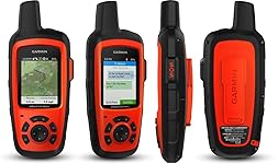
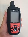
Garmin 010-01735-10 inReach Explorer+, Handheld Satellite Communicator with Topo Maps and GPS Navigation


Buy Now, Pay Later
- – Up to 36-month term if approved
- – No impact on credit to apply
- – Instant approval decision
- – Secure and straightforward checkout
Ready to go? Add this product to your cart and select a plan during checkout.
Payment plans are offered through our trusted finance partners Klarna, Affirm, Afterpay, Apple Pay, and PayTomorrow. No-credit-needed leasing options through Acima may also be available at checkout.
Learn more about financing & leasing here.
FREE 30-day refund/replacement
To qualify for a full refund, items must be returned in their original, unused condition. If an item is returned in a used, damaged, or materially different state, you may be granted a partial refund.
To initiate a return, please visit our Returns Center.
View our full returns policy here.


Features
- 100 percent global Iridium satellite coverage enables two way text messaging from anywhere (satellite subscription required)
- Trigger an interactive SOS to the 24/7 search and rescue monitoring center
- Track and share your location with family and friends. Water rating : IPX7. Battery : Rechargeable internal lithium ion
- Pair with mobile devices using the free earthmate app for access to downloadable maps, U.S. NOAA charts, color aerial imagery and more
- In reach explorerplus device adds preloaded Delorme topo maps with onscreen GPS routing plus built in digital compass, barometric altimeter and accelerometer
Description
You may venture off the grid, but you’re never out of reach as long as you’re carrying an inReach SE or inReach Explorer. These handheld satellite communicators are designed for the outdoor enthusiast who wants to roam farther and experience more without compromising their loved ones‘ peace of mind. From backcountry experiences to international adventures, inReach provides communication, location sharing, navigation and critical SOS functions for anyone who loves getting away from it all, on land, water or in the skies.
Brand: Garmin
Vehicle Service Type: Car
Screen Size: 2.3 Inches
Special Feature: Bluetooth
Connectivity Technology: Bluetooth
Map Type: North America
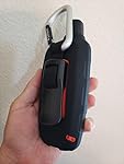
Included Components: USB cable, caribiner clip, documentation, inReach Explorer+
Audio Output Mode: Digital
Battery Life: 30 Hours
Mounting Type: Handheld
Compatible with Vehicle Type: Car
Screen Size: 2.3 Inches
Additional Features: Bluetooth
Connectivity Technology: Bluetooth
Map Types: North America
Sport Type: Outdoor Lifestyle
Audio Output Mode: Digital
Battery Average Life: 30 Hours
Mounting Type: Handheld
Resolution: 200 x 265
Touch Screen Type: Capacitive
Display Type: 200 x 265 pixels
Human-Interface Input: Buttons
Compatible Devices: Smartphone
Control Method: App
Are Batteries Included: Yes
Supported Satellite Navigation System: GPS
Connectivity Protocol: Bluetooth
Brand: Garmin
Built-In Media: USB cable, caribiner clip, documentation, inReach Explorer+
Model Year: 2017
UPC: 753759183530 753759168704 099654998863
Manufacturer: Garmin
Item Type Name: Garmin inReach Explorer+, Handheld Satellite Communicator with TOPO Maps and GPS Navigation
Unit Count: 1.0 Count
Item Dimensions L x W x H: 2.7"L x 1.5"W x 6.5"H
Item Weight: 8 ounces
Frequently asked questions
To initiate a return, please visit our Returns Center.
View our full returns policy here.
- Klarna Financing
- Affirm Pay in 4
- Affirm Financing
- Afterpay Financing
- PayTomorrow Financing
- Financing through Apple Pay
Learn more about financing & leasing here.
Similar Products


Top Amazon Reviews