Search  for anything...
NA

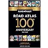
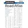
Rand McNally 2024 Large Scale Road Atlas - 100th Anniversary Collector's Edition (The Rand McNally Large Scale Road Atlas)

  • Based on 3,271 reviews
Condition: Used - Very Good
Checking for the best price...

Buy Now, Pay Later


As low as $9 / mo
  • – 4-month term
  • – No impact on credit
  • – Instant approval decision
  • – Secure and straightforward checkout

Ready to go? Add this product to your cart and select a plan during checkout.

Payment plans are offered through our trusted finance partners Klarna, PayTomorrow, Affirm, Afterpay, Apple Pay, and PayPal. No-credit-needed leasing options through Acima may also be available at checkout.

Learn more about financing & leasing here.

Free shipping on this product

This item is eligible for return within 30 days of receipt

To qualify for a full refund, items must be returned in their original, unused condition. If an item is returned in a used, damaged, or materially different state, you may be granted a partial refund.

To initiate a return, please visit our Returns Center.

View our full returns policy here.


Availability: Only 3 left in stock, order soon!
Fulfilled by WIDE WORLD MAPS and MORE!

Arrives Sep 27 – Oct 1
Order within 7 hours and 57 minutes
Available payment plans shown during checkout

Description

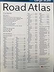
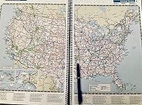
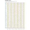
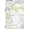
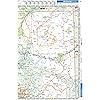
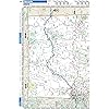
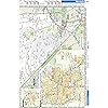
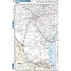
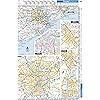
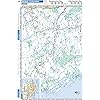
Beginning with it’s predecessor, the Auto Chum in 1924, the Rand McNally Road Atlas has been the essential, trusted tool for road travelers for 100 years. Celebrating its centennial anniversary, this 2024 Special Collector’s Edition features a custom cover showcasing Road Atlas covers throughout the years. This spiral-bound Large Scale edition featuring all the accuracy you’ve come to expect from Rand McNally, only bigger. This updated 2024 edition contains maps of every U.S. state, plus expanded coverage of Canada and Mexico, that are 35% larger than the standard atlas version. Includes over 350 detailed city inset and national park maps and a comprehensive, unabridged index. Road construction and conditions contact information for every state are conveniently located on map pages. Contains mileage chart showing distances between 77 North American cities and national parks with driving times map. Tough spiral binding allows the book to lay open easily. Other Features: A convenient page locator map on the inside cover makes it quick and easy to find the map you need. Tell Rand! As much as we work to keep our atlases up to date, conditions change quickly and new construction projects begin frequently. If you know of something we haven’t captured in our atlas, let us know at randmcnally.com/tellrand. Tourism websites and phone numbers for every U.S. state and Canadian province on map pages. Product Details: Dimensions: 10 3/8 x 15 3/8. Read more

Publisher ‏ : ‎ Rand McNally; Collectors edition (April 17, 2023)


Language ‏ : ‎ English


Spiral-bound ‏ : ‎ 286 pages


ISBN-10 ‏ : ‎ 0528027190


ISBN-13 ‏ : ‎ 92


Item Weight ‏ : ‎ 2.6 pounds


Dimensions ‏ : ‎ 10.5 x 0.75 x 5 inches


Best Sellers Rank: #20,481 in Books (See Top 100 in Books) #89 in Atlases & Maps (Books)


#89 in Atlases & Maps (Books):


Customer Reviews: 4.7 4.7 out of 5 stars 3,271 ratings


Frequently asked questions

If you place your order now, the estimated arrival date for this product is: Sep 27 – Oct 1

Yes, absolutely! You may return this product for a full refund within 30 days of receiving it.

To initiate a return, please visit our Returns Center.

View our full returns policy here.

  • Klarna Financing
  • Affirm Pay in 4
  • Affirm Financing
  • Afterpay Financing
  • PayTomorrow Financing
  • Financing through Apple Pay
Leasing options through Acima may also be available during checkout.

Learn more about financing & leasing here.

Top Amazon Reviews


  • Extra large
This road atlas is very large. It is great to keep at home in case you need to make copies for directions, to take on road trips in the event you lose cell service in mountains, or to teach your kids geography of the United States. It is extremely detailed. The quality of the book is great.
Reviewed in the United States on June 21, 2024 by Amazincustomer😀 Amazincustomer😀

  • Excellent when combined with Onstar!
This came just four days before we left for Mississippi on a much needed vacation. Larger print, easier to read and covering all the states. We were able to coordinate our travel plans between the Atlas and Onstar. We wanted to travel some backroads and we’re not much on iPhone’s so this was a fun way to go. The maps include lots of interesting places to see. The harder cardboard ring type binder helps to protect the pages. It’s nice to know that I’ve still “got it” and can read a map. ... show more
Reviewed in the United States on April 19, 2024 by Judy A.

  • Road Atlas
The Atlas is very detailed, in some cases too detailed as it is a little confusing to me but that's my problem. I'm used to an individual state map. It's not a big deal but I thought the pages should have been laminated and it has some weight to it. Overall it's very informative.
Reviewed in the United States on June 1, 2024 by Michael Baker

  • Great road trip companion
Very helpful and easy to read. My husband likes this better than the internet while riding. Much easier to read than a phone for long distance travel.
Reviewed in the United States on June 8, 2024 by Diane

  • Good atlas for normal use!
Need for a trip across the U. S
Reviewed in the United States on May 4, 2024 by Jim B

  • Brings back fond memories of days gone by
Bringing back fond memories of childhood car trips, the Rand McNally map is a nostalgic gem that's as reliable as ever. As I unfolded its familiar pages, I was transported back to the excitement of tracing our family's route across the country, marking off each milestone along the way. The detailed cartography and sturdy construction are a testament to Rand McNally's commitment to quality, standing the test of time just like those cherished memories. Whether planning an epic road trip or simply reminiscing about days gone by, this map is a timeless companion that never fails to evoke a sense of adventure and nostalgia. ... show more
Reviewed in the United States on April 12, 2024 by Archery Coach

  • Love this Beautiful A Road Atlas, easy to read, large scaled
Always need something for those time when GPS or phone GPS stops working because you are in the mountains or in a very rural area. Helps to know if I am traveling the correct way or if I needed to turn. Not mention the Road Atlas is easy to read and Large Scaled. It had your mileage chart, National park systems, counties, zip codes, populations ... show more
Reviewed in the United States on April 13, 2024 by ADJ

  • A must have for long drives
I've learned- the hard way- a GPS is NOT a reliable resource for directions. This is especially true when driving through large metropolitan areas. I first experienced this GPS "quirk" on I-95 approaching Washington DC. I've done this several times and the GPS consistently provides the wrong directions... It is very frustrating. I've experienced this driving through DC .... and other areas as well (i.e. New York). Having had these bad experiences with GPS, I bought the Rand McNally Road Atlas. Prior to going through a large metropolitan area, I now use the Atlas to determine the best route. If it conflicts with GPS directions, I use the Rand McNally directions. It's a more reliable solution. I like this version because it's spiral bound and encompasses the entire US. ... show more
Reviewed in the United States on February 20, 2024 by Charlie

Can't find a product?

Find it on Amazon first, then paste the link below.
Checking for best price...