Search  for anything...

Handheld GPS for Hiking, Rugged and Waterproof Handheld GPS Navigator, 3.2" Sunlight Readable Screen, Compact Satellite Handheld GPS with USA Topo Map, Multi-GNSS Support, Extra Battery Life

  • Based on 0 reviews
Condition: New
Checking for the best price...
$159.99 Why this price?

Buy Now, Pay Later


As low as $26.67 / mo
  • – 6-month term
  • – No impact on credit to apply
  • – Instant approval decision
  • – Secure and straightforward checkout

Ready to go? Add this product to your cart and select a plan during checkout.

Payment plans are offered through our trusted finance partners Klarna, Affirm, Afterpay, Apple Pay, and PayTomorrow. No-credit-needed leasing options through Acima may also be available at checkout.

Learn more about financing & leasing here.

Free shipping on this product

FREE 30-day refund/replacement

To qualify for a full refund, items must be returned in their original, unused condition. If an item is returned in a used, damaged, or materially different state, you may be granted a partial refund.

To initiate a return, please visit our Returns Center.

View our full returns policy here.


Availability: In Stock.
Fulfilled by Amazon

Arrives Friday, May 15
Order within 8 hours and 32 minutes
Available payment plans shown during checkout

Protection Plan Protect Your Purchase
Checking for protection plans...

Features

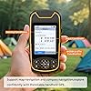
  • Compact and lightweight GPS handheld navigator boasts an anti-slip design offering a bright 3.2" screen that is sunlight readable, even in bright sunlight, plus, physical buttons provide more versatility in any conditions
  • Get multi-GNSS support(GPS+GALILEO+BEIDOU+QZSS) for superior positional accuracy,so you know exactly where you are,location precision within 6 ft
  • The handheld GPS navigator uses GPS technology to capture your trip or waypoint so you can guide back to your starting position
  • Equip with 3-axis compass and barometric altimeter,follow your bearing on the digital compass, which provides an accurate heading even when stationary
  • Hike in any weather with the water-resistant design (rated to IP66) ,Rechargeable battery can provide up to 36 hours of battery life in full charge, recharge easily with a standard USB-C cable
  • Preloaded with USA Topo maps for outdoor hiking and camping , 32 GB of internal memory for map downloads

Brand: NiesahYan


Model Name: NiesahYan


Screen Size: 3.2 Inches


Special Feature: Waterproof


Connectivity Technology: USB


Map Type: Topographical


Battery Life: 36 Hours


Mounting Type: Handheld


Operating System: Windows


Memory Storage Capacity: 32 GB


Screen Size: 3.2 Inches


Additional Features: Waterproof


Connectivity Technology: USB


Map Types: Topographical


Battery Average Life: 36 Hours


Mounting Type: Handheld


Operating System: Windows


Memory Storage Capacity: 32 GB


Touch Screen Type: Non-touchscreen


Display Type: LCD


Human-Interface Input: Buttons


Control Method: Push Button, Touch


Are Batteries Included: Yes


Supported Satellite Navigation System: BeiDou, GPS, Galileo, QZSS


Brand: NiesahYan


Model Name: NiesahYan


Manufacturer: NiesahYan


Frequently asked questions

If you place your order now, the estimated arrival date for this product is: Friday, May 15

Yes, absolutely! You may return this product for a full refund within 30 days of receiving it.

To initiate a return, please visit our Returns Center.

View our full returns policy here.

  • Klarna Financing
  • Affirm Pay in 4
  • Affirm Financing
  • Afterpay Financing
  • PayTomorrow Financing
  • Financing through Apple Pay
Leasing options through Acima may also be available during checkout.

Learn more about financing & leasing here.

Top Amazon Reviews


  • Have computer skills
I had to take it to someone to show me how to use it. Directions not to good. Even online directions are the same.
Reviewed in the United States on April 25, 2026 by Lee

  • Zoom in more
The GPS works real good. I just wished it would zoom in a little more on your position other than that. Satisfied with the product
Reviewed in the United States on January 22, 2026 by gsbobby

  • So glad I bought this
My fiance is a ADK 46rd He climbs almost every weekend. We lose at atleast one person a year to the Adirondacks. I get worried about him when he hikes. This has been able to give me a great peace of mind. My fiance is not a very technical person and he was able to figure out how to work this GPS with little to no effort. This was one of those gifts that you hope you're loved one never needs it but the security of knowing they have it is worth every penny ... show more
Reviewed in the United States on February 24, 2026 by Sue L.

  • OK!
OK!
Reviewed in the United States on February 8, 2026 by Theodoros T.

  • All is good.
Love the item
Reviewed in the United States on February 28, 2026 by Benjamin A.

  • I was so hopeful, but alas....
The media could not be loaded. A total bust and useless. I tried so hard with this company. I have purchased two GPS versions from this company. The first was so poor(UTM coordinates and zone incorrect, no bearings given, no proper Waypoint spatial plot, mirror imaging, no point naming, rubber C plug would not reset, about everything that could be wrong was. Only the lat long values for a given real time location were correct. So I decided to give them another chance and bought this higher end model. Still lots of problems, but also noticeably improved from the earlier version, at least for basic functions, and so I had higher hopes. Spent hours and hours learning what type of gpx file could be accepted (very primitive, version 1.0 gpx standards) so figured I could at least put it to basic use. First field test today. Entered one waypoint today and turned it off. Went to use for a second point, and the device will not boot up. Infinite loop up bootup screen and then shutdown. Cannot even turn off and on. Reset button has no impact (a hard reset button to factory defaults is required, not a soft reset like it has). It is not even going to be easy to return for me because of lifestyle, location and access to town services. Spent well over $350 on this company giving them a chance as Garmin deserves some competition but I do not have money to burn like this. Cannot even mildly recommend any products at this time; they need to do their homework more and also field test. The screen brightness, screen size, and legibility could have been a dream if it would have worked. Sorry Charlie, you can bet I tried more than you would ever know.... ... show more
Reviewed in the United States on January 5, 2026 by Clifford Carnicom

  • Cumple con lo que dice
Comprado desde Colombia para hacer medidas de diversos predios, de momento bastante bien, no tiene nada que ver qué sea de estados unidos los mapas, trazar rutas, tomar puntos, medir áreas, todo bastante intuitivo
Reviewed in the United States on January 13, 2026 by Yan Carlos Jiménez Castellanos

  • First GPS unit, not too bad
First one that I have owned. It's pretty rugged but I think for me it would be nice if there was a clip. Batter so far has lasted a long time. Older graphics but pretty functional and easy to operate. The zoom feature on can definitely do better. It's hard to see the map on the small screen. Favorite feature would be the survey feature. Figuring a square area and so on. It's pretty nice and accurate. Takeaways: 1. Don't switch maps in a low 2. Auto select time zone doesn't adjust the clock 3. If your names are displaying in a different language, reload the map. Should fix it. No language adjustment in settings that I could find. 4. Comes preloaded with US maps per state. Loading more seems complicated but didn't try it. Something to consider taking it abroad 5. Make sure to change the units (km vs miles, etc) ... show more
Reviewed in the United States on March 10, 2026 by Pawel

Can't find a product?

Find it on Amazon first, then paste the link below.
Checking for best price...