Search  for anything...

Garmin GPSMAP 62St Handheld GPS Navigator

  • Based on 0 reviews
Condition: Used - Good
Checking for the best price...
$249.99 Why this price?
Holiday Deal · 73% off was $909.99

Buy Now, Pay Later


As low as $41.67 / mo
  • – 6-month term
  • – No impact on credit
  • – Instant approval decision
  • – Secure and straightforward checkout

Ready to go? Add this product to your cart and select a plan during checkout.

Payment plans are offered through our trusted finance partners Klarna, Affirm, Afterpay, Apple Pay, and PayTomorrow. No-credit-needed leasing options through Acima may also be available at checkout.

Learn more about financing & leasing here.

Selected Option

Free shipping on this product

This item is eligible for return within 30 days of receipt

To qualify for a full refund, items must be returned in their original, unused condition. If an item is returned in a used, damaged, or materially different state, you may be granted a partial refund.

To initiate a return, please visit our Returns Center.

View our full returns policy here.


Availability: Only 1 left in stock, order soon!
Fulfilled by CoJack407

Arrives Wednesday, Dec 31
Order within 16 hours and 40 minutes
Available payment plans shown during checkout

Protection Plan Protect Your Purchase
Checking for protection plans...

Edition: 3.5GB Compass & Altimeter


Features

  • Rugged, waterproof navigator with 2.6-inch, sunlight-readable, 65-K color TFT screen and 160 x 240 pixel resolution
  • Three-axis, tilt-compensated electronic compass and barometric altimeter for precise bearing and altitude measurements
  • 100k topographic data for the U.S. and worldwide basemap with shaded relief; add a wide array of topographic, marine and road maps
  • Supports BirdsEye Satellite Imagery (subscription required) for integrating satellite images with your maps
  • Compatible with Custom Maps, free software that transforms paper and electronic maps into downloadable maps for your device
  • 2.6 in. transflective, 65-K color TFT display
  • Rugged, waterproof navigator with 2.6-inch, sunlight-readable, 65-K color TFT screen and 160 x 240 pixel resolution
  • Three-axis, tilt-compensated electronic compass and barometric altimeter for precise bearing and altitude measurements
  • 100k topographic data for the U.S. and worldwide basemap with shaded relief; add a wide array of topographic, marine and road maps
  • Supports BirdsEye Satellite Imagery (subscription required) for integrating satellite images with your maps
  • Compatible with Custom Maps, free software that transforms paper and electronic maps into downloadable maps for your device

Description

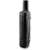
The Garmin GPSMAP 62ST Waterproof Handheld Navigator with 100K Topo Maps features a 3-axis tilt-compensated compass, a barometric altimeter, preloaded 100K topo maps and supports Custom Maps, BirdsEye Satellite imagery (subscription required) and photo navigation. Rugged and waterproof, this navigator employs a quad helix antenna for unparalleled reception, has a high- speed USB connection, a sleek new design and connects wirelessly to compatible Garmin handhelds. It comes with built-in U.S. 100k topographic data for the continental U.S. and a worldwide basemap with shaded relief — all the tools for serious climbing or hiking. Map detail includes national, state and local parks and forests, along with terrain contours, elevation information, trails, rivers, lakes and points of interest.

Brand: Garmin


Model Name: 62st


Vehicle Service Type: Car, Truck, Motorcycle, Bicycle, etc.


Screen Size: 2.6 Inches


Special Feature: Explore the Terrain, Get Your Bearings


Connectivity Technology: USB


Map Type: Street;Topographical


Included Components: Garmin GPSMAP 62ST handheld navigator, USB cable, and user manual


Battery Life: 20 Hours


Mounting Type: Wrist Mount, found in image


Product Dimensions: 6.3 x 1.4 x 2.4 inches


Item Weight: 9.2 ounces


Item model number: 010-00868-02


Batteries: 2 AA batteries required.


Is Discontinued By Manufacturer: Yes


OS: Windows


RAM: 500 MB


Connectivity technologies: USB


Special features: Explore the Terrain, Get Your Bearings


Other display features: Wireless


Human Interface Input: Buttons


Scanner Resolution: 160 x 240


Color: One Color


Whats in the box: Garmin GPSMAP 62ST handheld navigator, USB cable, and user manual


Department: mens


Manufacturer: Garmin


Date First Available: June 2, 2010


Frequently asked questions

If you place your order now, the estimated arrival date for this product is: Wednesday, Dec 31

Yes, absolutely! You may return this product for a full refund within 30 days of receiving it.

To initiate a return, please visit our Returns Center.

View our full returns policy here.

  • Klarna Financing
  • Affirm Pay in 4
  • Affirm Financing
  • Afterpay Financing
  • PayTomorrow Financing
  • Financing through Apple Pay
Leasing options through Acima may also be available during checkout.

Learn more about financing & leasing here.

Top Amazon Reviews


  • Easily the best non-Mapping GPS unit I've ever used.
Edition: 3.5GB with Camera
Prior to the 62sc, my experience with GPS units was bi-modal: I had extensive experience with a GPS72 and GPSV (both Garmin units) for personal use, biking, hiking, geocaching, etc and a Trimble GeoXT for general field GIS use; basic surveying, mapping, data collection, etc. The Trimble has insane accuracy and precision as you'd imagine to get from a $2k GPS, while the two garmins left a bit to be desired in that department. The GPS72 was my preferred GPS, as it was very easy to use and read, and, provided I was in an open enough area, got a lock relatively quickly. The GPSV got a lock a bit faster due to its helix antenna but it's awkward to hold. So, I just broke down and decided to buy a high end GPS. A lot of people told me to get one of the touch screen units, the Oregon or whatever, but I want one that I can use with gloves and not have to worry about the integrity of the screen. This unit is a bit expensive, but I have found it to be worth every penny. For one, it gets a lock very quickly and under almost any circumstances. My apartment is the bottom half of a split level in a valley in the Appalachian Mountains; the GPS72 and GPSV could barely get a lock in my back yard. The 62sc gets a lock with 30ft accuracy sitting on my couch! Its real test was my trip to southern Utah, where I went hiking in and around canyons. As soon as I turned it on it would get a lock with as many satellites as possible, reporting an accuracy of 7 to 9 feet. For a consumer GPS that's absolutely incredible! With my arms outstretched (I'm 6'5") I can essentially make a 7ft circle around myself. With my two older garmin units I'm used to an accuracy of 20-30ft in these situations, which was next to useless when trail mapping, though fairly useful for position reporting. Even in deep canyons (e.g. Zion) I could maintain a 7ft lock despite the hundreds of feet of rock walls on either side of me. This particular gpsmap 62 also comes with a carabiner clip which is the best thing ever. I can clip it to a belt loop and, despite looking like more of a dork than usual, I can have fast and easy access to the GPS and it's not at all in the way or is the antenna obstructed. I used to do something similar with the GPS72, but due to its patch antenna being opposite the lanyard loop, it would almost always lose a signal, so I was forced to hold on to it - something that gets to be a real nuisance when you're doing near-technical climbing! I was very suspicious of the altimeter, but I have been pleasantly surprised. When I first got it I hiked out to a nearby USGS benchmark and calibrated it, and since then it has been perfectly accurate to the foot. The same goes for the compass, very accurate, and very handy. The camera takes better pictures than I would have imagined, too. Here's an example from Utah: [...] It's a decent quality picture, especially from a 5MP camera with a tiny little lens. The field of view is much wider than I would like it to be, but if I just want to snap a quick picture and I don't have any other cameras with me, it's very useful - especially to have them be instantly geotagged. I put a cheap screen protector on it as soon as I got it because the screen looked to be covered by a softer plastic and I didn't want anything to happen to it. I haven't dunked it under water yet, but I have used it in heavy rain and snow with no issues whatsoever. Overall the screen is bright and easy to read in all conditions, including direct sunlight. Battery life has generally been exactly what garmin says it will be. I highly recommend serious users get a piece of software called G-Raster which will allow USGS and USFS quads to be easily made for the device, which is much cheaper (and yields much higher quality maps) than garmin provides at a very high cost. If you're handy with GIS you can also get free high resolution orthophotos from NRCS or NationalMap and put them on the unit, making it incredibly powerful. I think the only thing I don't like about this device is the fact that we're only allowed one custom map at a time, so you can't switch between orthophotos and quads and a custom map, they all have to be displayed at once. I imagine this is because they want you to buy their products. ... show more
Reviewed in the United States on December 23, 2012 by John Miller

  • Better Than Expected
Edition: 1.7GB Compass & Altimeter
After reading many of the reviews here, I was expecting to have some issues with the 62s, but I went ahead and bought it because a friend had one and it passed his high standards. So far, I've only had one small problem with it. I got the 62s to replace my 60csx because I wanted a better device for geocaching. In that regard, it is a vast improvement over the 60csx. I used to have to take my smart phone with me and use both devices to find a cache. Now, the 62s has all the information I need. When I got the device, I plugged into my OS X computer and brought up Base Camp. It immediately told me there was a software update. I had to download an app from Garmin to do the update. After doing so, the upgrade was a breeze. I also uploaded a non-garmin map to it using Garmin Map Install without any issues. Some reviews complained of a difficult interface. After the 60csx, I found it easy to use. It only took me a few minutes to get comfortable with it. Full disclosure: I have 40+ years programming experience and was the go to guy to assemble toys at Christmas. The interface is more complex as there are more options. For regular use, you generally don't have to access them. A nice improvement is the ability to customize the interface. I dropped several screens from the standard rotation making it easier to get to the ones I want. The only problem I have with the interface appears to be a bug in paging. At the completion of a search for a geocache that I decide to cancel by selecting Stop, I can't navigate to another page. When I press Page, I see all the other pages and can select one. When I do, it just returns to the compass page. The way around the problem is to select the compass page first. After that, it works fine. My friends 62s doesn't do this. I also read about complaints about the case creaking. I don't have this problem with mine. This may have been something they fixed in production since the product came out. I also read complaints about the battery level indicator going from full charge to no charge quickly. I've only discharged it once. The device was at full charge when I started out on my last outing. I wasn't checking the charge as I went along until I got a message that the batteries were low and that the back light would be turned off. At that point, the charge was down to two bars. I continued to use it for about an hour until it got down to one bar. At that point, I put in new batteries. I'm guessing I could have used it for a while longer before they went completely dead. Overall, I didn't find the performance any better or worse than my 60csx. I use alkaline batteries and my usual practice is to always carry an extra set with me when I'm out with the device. There appears to be one drawback in comparison to the 60csx when using the device to feed coordinates to a camera. They still supply a cable to do that, but it plugs into the USB port. From the look of the cable, it would stick straight out of the device like any other USB cable so you have to leave the flap open. My concern is that it would get in the way and be subject to getting bent. The cable for the 60csx plugged into another socket and came out at a right angle to the device. Another disadvantage of the new cable is that the other end is just bare wires. You would have to solder on a connector of your choice. My solution was to buy another GPS that mounted on my camera hot shoe. Even with the 60csx, the cable between the Garmin and the camera was a pain. In use, the 62s seems to lock onto to satellites faster than the 60csx and is slightly more accurate in zeroing in on a cache. These are just my opinions; I haven't done any formal testing. With both devices, I had problems in heavy tree cover. Overall this device is a vast improvement over the 60csx for the purpose of geocaching. My only complaint is the problem with the page switching,which hopefully can be fixed. ... show more
Reviewed in the United States on June 9, 2013 by William C. Rowe

Can't find a product?

Find it on Amazon first, then paste the link below.
Checking for best price...