


Buy Now, Pay Later
- – 6-month term
- – No impact on credit to apply
- – Instant approval decision
- – Secure and straightforward checkout
Ready to go? Add this product to your cart and select a plan during checkout.
Payment plans are offered through our trusted finance partners Klarna, Affirm, Afterpay, Apple Pay, and PayTomorrow. No-credit-needed leasing options through Acima may also be available at checkout.
Learn more about financing & leasing here.
Selected Option
30-day refund/replacement
To qualify for a full refund, items must be returned in their original, unused condition. If an item is returned in a used, damaged, or materially different state, you may be granted a partial refund.
To initiate a return, please visit our Returns Center.
View our full returns policy here.


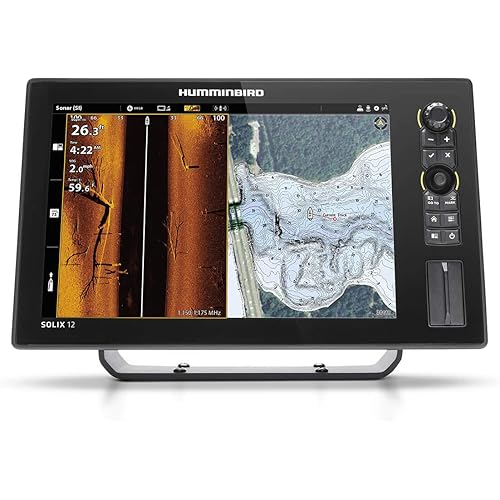
Style: Us Lakes South East
Features
- SHADED RELIEF: Bring the world around you to life, with 3D rendered land and underwater elevation including areas of Ultra-High-Res Bathymetric imagery a game-changer for anglers and divers.
- FULL-FEATURED VECTOR CHARTS: Making navigation easy by giving you accurate, up-to-date vector chart detail derived from official Hydrographic Office information.
- HIGH-RES BATHY: Helps you identify shallow areas, drop-offs, ledges, holes or humps. Now includes compiled and quality-controlled Genesis detail as part of singular HRB layer.
- CUSTOM DEPTH SHADING: Set a clear safety depth, maintain a paper-like view or create your own custom shading.
- EASY ROUTING: Helps you automatically plot the shortest, safest route based on detailed chart data and your personalized vessel information. No subscription required.
Description
Our REVEAL charts bring you the very best of C-MAP, including premium layers like Shaded Relief – bringing the world around and beneath you to life in a completely new way. Optimised for selected chartplotters from Lowrance , Simrad , & B&G.
Brand: C-MAP
Series: M-NA-Y214-MS
Item model number: M-NA-Y214-MS
Item Weight: 1.51 ounces
Product Dimensions: 5.79 x 4.13 x 0.2 inches
Item Dimensions LxWxH: 5.79 x 4.13 x 0.2 inches
Color: US Lakes Southeast
Manufacturer: C-MAP
Date First Available: December 30, 2020
Frequently asked questions
To initiate a return, please visit our Returns Center.
View our full returns policy here.
- Klarna Financing
- Affirm Pay in 4
- Affirm Financing
- Afterpay Financing
- PayTomorrow Financing
- Financing through Apple Pay
Learn more about financing & leasing here.


Top Amazon Reviews

